|
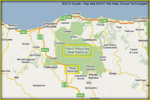
The regional Madonie Park,
covers 40 000 hectares of
natural woodland and
mountains in the province of
Palermo. The area is of
direct interest for nearly
15 municipalities and has
altitude ranging up to
2000m, reaching a high point
of 1979m at Pizzo Carbonara.
Thus the variety of
landscapes and plant and
animal wildlife is of great
natural and scientific
interest.
The mountain range is
located between the valley
of the river Pollina, to the
east, and the valley of
South Imera to the West. A
strech of Tyrrhenian
seashore to the north,
between Campofelice and
Roccella & Pollina, and the
high plateau to the south
complete its borders.
It is no exaggeration to
qualify the madonite area as
a botanical garden in the
heart of the Meditteranean.
It is also interestingly
referred to as a crossroads
between three continents.
In fact, over millions of
years, this area has been
favourable to the
development of hundreds of
native and exclusive species,
as well as a survival ground
for species native to other
areas, as distant as Central
and Northern Europe. The
Madonie is home to over half
of Sicily's species; a
figure topping 2600.
The geological structure of
the Madonie is also
heterogeneous in many ways:
structure, breadth, height,
hydrological structure,
exposure and climate. Thus
its landscapes are varied
and stunning, going from the
snow caps on the Carbonara,
second only to the Etna in
Sicily, to the wonderful
coastline of Cefalù.
The central part of the
chain features an extended
high plateau which connect
its major peaks. This
plateau appears devoid of
bodies of water. However,
this is due to the the
presence of numerous caves
and grottoes where water can
pursue its course without
having to see the light of
day. Thus providing
additional paths to track...
underground |